
 |
Walks
from How Hill
|

Walks that
start at How Hill
How Hill is a great
place to start a walk and there are lots of choices
available from short walks by the river to a range of
circles.There is a car park at How Hill and plenty of mooring for boats so it is an ideal starting point however you arrive.
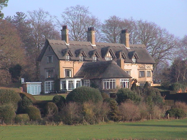
How Hill House is a study
center and is not open to the public except on a few
special events. However, the lawn in front of the house
is open all year round. It has this fantastic view:
Behind How Hill House near
the road is the entrance to the Secret Garden. These
lovely water gardens are open all year round free of
charge and are certainly worth a visit especially in the
spring.
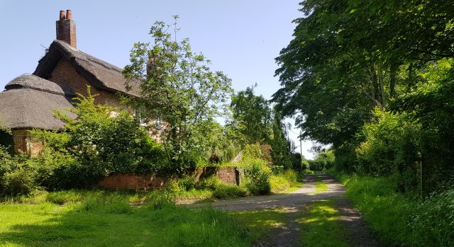
Close by is the the museum at Toad Hole cottage. It is well worth a visit and you can see the life of a marshman first hand. A nature trail starts from here and leads you through the How Hill estate to Crome's Broad. There is a small charge for this. The museum and nature trail are both closed in winter. The photograph below shows Toad Hole cottage.

Close by is the the museum at Toad Hole cottage. It is well worth a visit and you can see the life of a marshman first hand. A nature trail starts from here and leads you through the How Hill estate to Crome's Broad. There is a small charge for this. The museum and nature trail are both closed in winter. The photograph below shows Toad Hole cottage.
From Toad Hole cottage,
cross the bridge and you will find yourself on the
riverbank. This is How Hill staithe, a public mooring
place for boats. All our How Hill walks start from here.

Walk One - A Short Walk
to the Preserved Windmills or continue for a
circular walk via Sharp Street

The path to the mills has been improved and is no longer muddy

The Norfolk Hawker dragonfly can be seen on this path

Walk Two - How Hill to Ludham Bridge via Buttle Marsh
A pleasant riverside walk which takes you to the main road at Ludham Bridge. On the way, you pass Buttle Marsh, a newly created nature reserve which has scrapes and reedbeds designed to attract rare bitterns. About a mile along riverside paths, it can be muddy at times.
Start the walk at How Hill Staithe and follow the riverbank with the river on your right.
The short walk along the riverbank takes you to two preserved skeleton wind pumps. You can turn back here or continue along a permissive path, opened in 2019, which takes you on a 2 mile circle through marshes and the hamlet of Sharp Street. Just follow the riverside path to the right of the boathouse (see picture above). It is just a short distance to the preserved mills. The first mill you come to is Boardman's Mill which was used to drain the local marshes. The picture on the right shows the next mill, Clayrack Mill. It is a scoopwheel wind pump which was used to drain the marshes elsewhere and was moved here. It used to work but it is currently under repair. You can retrace your steps back to the staithe from here or you can continue on the circular walk. This walk crosses the marshes and is full of wildlife. |
 |
The path to the mills has been improved and is no longer muddy
The Norfolk Hawker dragonfly can be seen on this path
After the second mill, follow
the path down off the bank and onto a permissive
path which runs low down behind the river bank
with open marshes on the right.


Follow the path which eventually crosses the dyke leading the Crome's Broad on a metal drawbridge.

Follow the path which eventually crosses the dyke leading the Crome's Broad on a metal drawbridge.
Cross the bridge and follow
the path between the fences until you come
to a T Junction.

Turn left at the T
junction and follow the track to come to
the riverbank at a wild mooring spot.
Here you can watch the boats go by. Now
return to the T junction and go the
other way towards Sharp Street.

Keep following the
track past the farm. Eventually it
becomes as road. Follow this road to
the next junction where you turn
right.

Turn right here and
follow this road back to How Hill. You
will know you are there when you see a
large black mill on your left.
If you want a bit more exercise, it is possible to extend this walk further by taking the public footpath off to the left of the road. There are various paths you can follow. See our map on the walks index page.
If you want a bit more exercise, it is possible to extend this walk further by taking the public footpath off to the left of the road. There are various paths you can follow. See our map on the walks index page.
Walk Two - How Hill to Ludham Bridge via Buttle Marsh
A pleasant riverside walk which takes you to the main road at Ludham Bridge. On the way, you pass Buttle Marsh, a newly created nature reserve which has scrapes and reedbeds designed to attract rare bitterns. About a mile along riverside paths, it can be muddy at times.
Start the walk at How Hill Staithe and follow the riverbank with the river on your right.

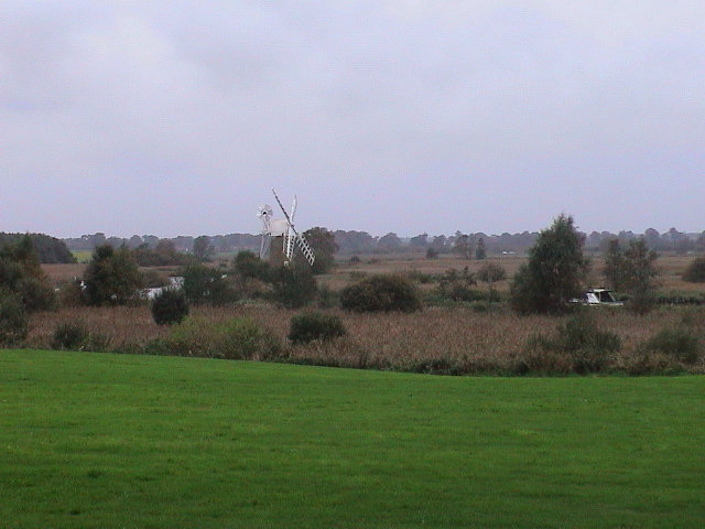
You get excellent views of
Turf Fen Mill and Reedham Water beyond it. The marshes
on the other side of the river are still cut for reed in
the traditional way. You can visit this area on a boat
called The Electric Eel. Enquire at Toad Hole cottage
for details of when the boat is operating. You usually
need to book in advance.

At the end of the moorings,
the path turns left and goes behind a reed bed. This
reed bed is a particular type of Broadland habitat where
the reeds are open to the rise and fall of the tidal
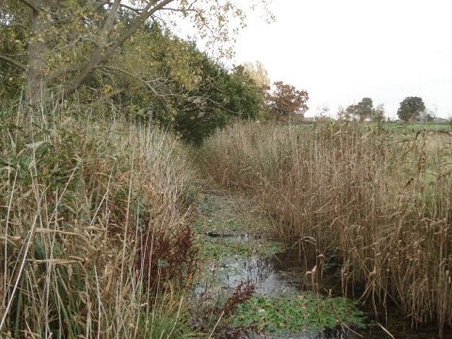
water. We have seen otters here, go quietly.

You now come to a junction of tracks where the path you are on dips down and joins a track coming in from the left. This is the main junction of paths where the various How Hill Walks diverge.

To continue to Ludham Bridge, take the path to the right at this point staying high up on the bank. Follow this path towards the riverbank and then follow the left hand of the two paths slightly back from the river. You will pass Buttle Marsh on your left and eventually arrive at Ludham Bridge.
You now come to a junction of tracks where the path you are on dips down and joins a track coming in from the left. This is the main junction of paths where the various How Hill Walks diverge.
To continue to Ludham Bridge, take the path to the right at this point staying high up on the bank. Follow this path towards the riverbank and then follow the left hand of the two paths slightly back from the river. You will pass Buttle Marsh on your left and eventually arrive at Ludham Bridge.
Walk Three. A Short Circle round How Hill
This short circular walk of about a mile follows public footpaths and country lanes to give you a quick view of the different habitats round How Hill.
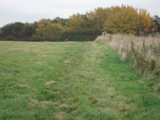
To start this walk, follow Walk Two until you come to the main junction of paths. Turn left at the junction and follow a well defined track between fences.
The track becomes a hollow
way passing between hedges and then turns right by a
house and becomes a country lane. Just beyond the house,
turn left into a public footpath and follow this path as
it curves through fields and crosses a bridge.
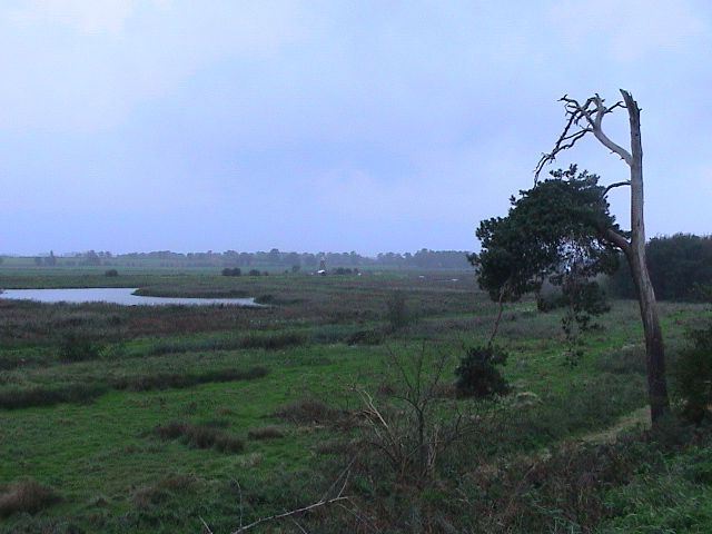
This is the view from the bridge. This area was once much more open and had a large pond. Now it has gradually turned into carr woodland. It is still quite wet and boggy.
Cross the bridge and follow the path through a hole in the hedge to a road. Turn left and follow the road past How Hill Farm back to the car park at How Hill.
Walk Four - How Hill to Ludham Village via The Clint.
An interesting walk into Ludham with good views of Buttle Marsh. About 2 miles, can be muddy in places.
To start this walk, follow Walk Two until you come to the main junction of paths. Go straight on through the gate opposite and follow the grassy track with woods on your left.
Continue along the track until you come to this gate where the public footpath turns sharp left and starts to rise up a hill. Turn left here and go up the hill with the fence on your right.

Pass through this gate and continue along the path
This is the view from the bridge. This area was once much more open and had a large pond. Now it has gradually turned into carr woodland. It is still quite wet and boggy.
Cross the bridge and follow the path through a hole in the hedge to a road. Turn left and follow the road past How Hill Farm back to the car park at How Hill.
Walk Four - How Hill to Ludham Village via The Clint.
An interesting walk into Ludham with good views of Buttle Marsh. About 2 miles, can be muddy in places.
To start this walk, follow Walk Two until you come to the main junction of paths. Go straight on through the gate opposite and follow the grassy track with woods on your left.
Continue along the track until you come to this gate where the public footpath turns sharp left and starts to rise up a hill. Turn left here and go up the hill with the fence on your right.
Pass through this gate and continue along the path

Continue up the hill
keeping the fence and woods on your right.
To your right, you have excellent views over Buttle Marsh, a special habitat created for bitterns. The cliff below you is called The Clint. It is hard to believe that there was once a railway running along here and the cliff bank was used for gunnery training in W.W.II.
To your right, you have excellent views over Buttle Marsh, a special habitat created for bitterns. The cliff below you is called The Clint. It is hard to believe that there was once a railway running along here and the cliff bank was used for gunnery training in W.W.II.
The path now becomes a more well defined track between hedges. After a short distance, you approach a farm yard.

Continue along the path and
through a farmyard with ruined barns on your left. Go
through the metal gate and continue downhill along the
road.

Just past the farmhouse,
turn left uphill into a narrow footpath between the farm
hedge and a wire fence.

At the top of the hill with a farm gate on your left, turn right into a track.
(If you are on Walk 5, the large circle, do not turn right here but go straight on following the public footpath until you meet a road.)
At the top of the hill with a farm gate on your left, turn right into a track.
(If you are on Walk 5, the large circle, do not turn right here but go straight on following the public footpath until you meet a road.)

Keep following this track until you reach a road junction.

Turn left here into the
narrow lane. Follow this lane which curves right past
houses and then leads you back to the centre of Ludham
Village.
Walk Five - The Large Circle via the Clint and
Sandy Loke.
An excellent circular walk of about 2 miles. Good views of Buttle Marsh
To start this walk, follow Walk 4. When walk 4 branches off to the right just past the farm house, continue straight on along the public footpath until you reach a road. Turn right here and follow the road slightly uphill until you are almost at the road junction.
Just before the road junction where the hedge starts on your left, turn left downhill along a broad track with an open field on your left and a hedgerow with tall trees on your right. This is called Sandy Loke.
At the end of Sandy Loke, pass through a belt of trees and meet a road. Turn left here and follow the road back to How Hill.