
 |
|
Introduction
Meetings of the Workers Educational Association (WEA) were a regular feature of Ludham social life for many years. Villagers would attend evening classes where a speaker would enlighten and teach us about a wide range of subjects ranging from the arts to the sciences. Indeed the meetings only stopped relatively recently when the money ran out.
Back in 1980, members attended a course on industrial archaeology. As part of their studies, they produced a document called A Survey of Ludham. The document was typed and contained drawings of items of interest.
The survey is of interest as it contains a potted history of the village as well as a survey of business life in the area. It was a well researched and produced document. Obviously, it is a bit out of date now as much has happened since, but nevertheless it is a very useful document for historians an contains much of general interest too.
The text of the survey and the drawings are below. We hope you find this useful.
No 2 in an occasional series of village surveys
TG 388 183
Ludham, like Flordon, the first village surveyed in this
series, runs true to its type: a Norfolk village on a
site settled at least as early as Saxon times; with a
stable population showing growth in recent years; with
strong links with the Church; and with a wide variety of
trades and industries which made for self-sufficiency. 1. Historical Background
Ludham (Luda's Ham, i.e. Luda's manor or town) is a Broadland village, thirteen miles N by NE of Norwich. It is thought to be of Saxon origin, with the church on high ground, the manor to the east and a row of dwellings on either side of the street. Stocks Hill could well have been enclosed and stockaded in order to protect livestock and inhabitants from raiders.
The Pulk, a freshwater stream on a line running due north, to the west of the village, runs into Womack Water.
Although the present church, St. Catherine's, is fourteenth to fifteenth century, there was an earlier church on the site, for in 1220 AD the church was taken over by St. Benet's Abbey. There were also two other chapels in existence at the time, namely St. Mary Virgin and St. John.
A fair was procured for Ludham in Elizabeth I's reign and traditionally held on Thursday and Friday after Trinity Sunday. The Fair was still held until quite recently.
There were three manors in Ludham; Ludham Bacons (now the Grange), Walton Hall and Ludham Grange (now Ludham Hall farmhouse). Ludham Grange, belonging to St. Benet's, was partly destroyed by fire in 1611 AD, but was restored with the now disused chapel (now a granary) adjoining. It was for a time the chapel of the Bishop of Norwich.
The Abbey of St. Benet's was never finally dissolved and the present Bishop of Norwich is the Abbot of St. Benet's. It seems that a small, monastery was first established on the Abbey site by Saxon monks led by Sunemen in 800. Destroyed by the Danes in 870, it was refounded and rebuilt by Wulfric c. 966 and Canute gave a charter to the Abbey in 1019.
Agriculture was served by three corn mills, at High Mill, at How Hill, and at Lover's Lane. Brickmaking was served by brick kilns at Womack, How Hill and the hill on Yarmouth Road.
Ludham was recorded in Doomsday Book 1086, with 171/2 freeman, 1351/2 soke men (free peasants), 15 villeins (peasants), 25 bondars (cottagers), 2 serf (slaves); hence a population of, say, 195 x 4 = 780.
The first census in 1801 records 724 population, and between then and 1965 the population varied between 639 in 1901 (emigration to Canada?) and 996 in 1951. The next census will definitely record an increase to over 1,000
2. Farming
Ludham was a village of just under 3,000 acres of mixed farming, with some marshland suitable only for grazing. Notable cattle were bred here and exhibited all over the country and at all the principal centres on the continent.
In 1945 there were eighteen farms, twelve of these being owner-occupied. There were twelve farmers only by 1888. Some of the smaller farmers combined agriculture with a secondary occupation, e.g. maltster, corn and coal merchant, victualler, carpenter and even shoemaker.
After World War I, between 1922 and 1925, under a government scheme to provide work for returned soldiers, Norfolk County Council compulsorily purchased land from some of the larger farms to set up 500 acres of smallholdings. By 1929 there were eleven smallholders, but by 1937 the number had dropped to four, since to make a living on the smaller holdings had become increasingly difficult in the recession of the 1930s.
In World War II the area of smallholdings was requisitioned by the government and an airfield established there. The firefighting headquarters buildings and the control tower remain from this period. Subsequently the site has been divided into two farms and Westwick Crop Sprayer has an airfield there.
In a sale record of 1842 it is stated that the quality of the land - and game - is excellent, and that as the result of the 1840 Enclosure Act, 200-300 acres may be made productive 'in the present improved state of drainage by steam'.
Sugar beet grown in the area was loaded on to wherries for transport to the Cantley factory from Womack Water until about 1955. Of course, now, road transport is used.
3. Ludham Airfield, TG 395 195
Much of the land incorporated in the airfield from the smallholdings was Church property, for which an annual rent of £50 was received.
Ludham Airfield was a second satellite of Coltishall, coming into use in late 1941 as a forward base for fighter squadrons operating under
Coltishall control. Convoy patrol and bomber escort were its main function. On August 13, 1943, the base ceased to operate and passed to Air Ministry Works, intended to be handed over to the U.S. Air Force. However, this never happened and in August 1944 the Royal Navy began using the station as 'H.M.S. Flycatcher', a base for Middle Wallop, Hampshire. R.A.F. fighters returned in February 1945, resuming attacks on V2 launching sites and escort duties. In 1945 Mk. XXI Spitfires came to Ludham, making armed reconnaissance particularly against midget submarines. Ludham was closed late in 1945.
4. Corn Mills and Windpumps
Norfolk and windmills seem to go together as naturally as bread and butter. And indeed, at one time they were as essential to living as bread is to man.
Stand anywhere on the flat lands of the Ant and Bure valleys and sweep the eye in an arc to the horizon; the shadows of four or five or more derelict and truncated mills can be seen rising up in the mist. Occasionally one can be seen standing proudly in all its glory sails spread wide to the sky, inviting the wind to set it in motion and bring life to its outmoded machinery. To the uninitiated a mill is a mill - a mill is a grain mill for grinding corn. But looking across the flat lands one can follow the course of a river by the mills dotted along its banks. They seem to be sitting in the marshes where the land is too wet for wheat. These mills are the drainage mills which are a distinctive feature of this part of England. Before the days of electricity they were used for draining the marshes.
On slightly higher land and close to habitation are the remnants of the old corn grinding mills. Often these seem to be in a better state of preservation than the drainage mills, possibly because, they are better protected for use as dwellings or even storehouses, or restored as museums of great interest. Sutton Mill, quite near to Ludham, is one of these.
The village of Ludham, which sits in the valleys of the rivers Ant and Bure, once had many mills of both kinds; there were seven windpumps and three corn mills.
Two windpumps were situated on the Horse Fen marshes:
Horse Fen windpump, near Potter Heigham boundary, approximately one mile upstream from Womack dyke: a brick tower windpump with patent sails, built by Dan England, date unknown, fitted with a scoop wheel;
Womack windpump: a brick tower windpump with cloth sails, builder unknown; this windpump had an all-wood windshaft (derelict tower remains).
Coldharbour windpump, situated approximately a quarter of a mile downstream from Womack Dyke: built by Dan England, date unknown, fitted with a scoop wheel (no remains).
Trestle windpump, Boardman's Marsh, How Hill: designed and built by Dan England, 1897. It was built to replace a windpump which stood on the same site. The following note was found on the back of Dan England's drawings:
'Specification. March 31st, 1897.
To take down the present windpump and the brick pillars and water wheel hood and clear the water wheel and erect a large smock tower windpump with 4 patent sails and gear. To provide and fix 4 large brick Pillars 6 ft. high with 4 holding down bolts and to fix wood planks to each pillar.'
Unfortunately, no price was given. This trestle mill is now taken over by the Norfolk Windmill Trust and is being preserved.
Ludham Bridge windpumps:
a) One situated 200 yards downstream from the bridge; built by Dan England, fitted with a scoop wheel, demolished beginning of last war (date when built unknown);
b) The other one 150 yards upstream, date and builder unknown, was used as a look-out and gun post during the last war; tower of windpump still standing.
How Hill Staithe windpump: standing on opposite bank within boundary of Irstead; fitted with two scoop wheels; builder and date unknown; listed for preservation by Norfolk Windmill Trust. It had patent sails.
High Mill 'Corn'; builder unknown. Believed built 1742. This date is considered about right. There is an advertisement copy in Norwich library for the mill dated 1771. This corn mill had an interesting feature. The sails of the great majority of mills rotate opposite to the hands of a clock when you face them. This mill was one of the very few which rotated clockwise. Tower converted to a garage 1932. Mill ceased working 1926.
Ludham Town Mill, 'Corn'; builder unknown. Situated just off Lovers' Lane; severely damaged in great gale, 24 March 1896; rebuilt and destroyed by fire 1898. The great gale of 1896 was remembered by one or two older members of the village I have spoken to Mr Albert Warner who was a lad of ten when it happened said "Ludham main street was covered with thatch and tiles from the houses and water was sucked up from the rivers", so great was the wind force.
How Hill Corn Mill: built 1823; builder unknown. Working until 1890, sails removed 1893. A water tank was later installed in the tower for Mr. Boardman's fruit farm.
Englands, Millwrights
As far as I know, there is no early history of the drainage of the marshes. Research into the history of St. Benet's Abbey in 1967 found some reference to embanking there during the twelfth century. Apart from this, little is known. We do know that windpumps were used for drainage, going back about three hundred years. At one time as many as eighty could be counted from Ludham to Norwich by river.
These were built by Norfolk Millwrights. There were several firms of millwrights in the Broads district:
Robert Barnes of Yarmouth
William Rust, Martham
Thomas Smithdale, Acle
William Thomas England of Yarmouth, formerly of Ludham; nephew of Daniel England, 1823-97
Edmund Stolworthy, also of Yarmouth
One of the largest firms in Norfolk was Englands of Ludham. During their time as millwrights they did all the drainage work for Ludham, which covered work for the Ecclesiastical Commissioners, Norwich Union and other big landowners. Their work covered a large part of Norfolk on estates for Lord Somerleyton, Suffolk, and Sir Thomas Beauchamp of Langley.
During the last century Englands employed fifteen to twenty men. There are records of 19 windpumps built by them and no doubt they built many more. Unfortunately, all records are lost.
The workshops were situated in the centre of the village where Clarke' garage now stands and extended round the back to within a few yards of the King's Arms. The buildings were of wood and corrugated iron and covered about three-quarters of an acre. The tools they used were much the same as in other trades in wood and iron at that time.
It is said that a millwright had to be a steeplejack, architect, carpenter, bricklayer and blacksmith, all in one. Not for them going on strike because one man was doing another's job: Their work was particularly dangerous, working as they often did in water or from considerable heights. Two members of the family lost their lives doing this work. They had to know how to lift a windshaft, weighing anything up to two tons or more, to the top of a corn mill, all by hand. No mobile cranes in their day:
All the small foundry jobs were done at Ludham, but larger items wen cast at Pertwee and Backs' foundry, Gt. Yarmouth.
I can remember seeing two sawpits. Later, at the turn of the century some machinery was installed. This was operated by a diesel engine. An iron shaft ran overhead, the whole length of the workshop, with wheels at intervals, and leather belts connected these to the lathes and saws. As a boy I used to spend many hours around the workshops. I was forbidden to go near when the diesel engine was working. When the engine started up the whole building would shake until the gear gathered speed.
All transport to the mills was by horse and cart. Dan England was the first man in Ludham to generate and use electricity in his workshops.
The earliest windpumps were of wooden construction, called smock mills. These had cloth sails and operated by means of a tail pole. Later came the brick tower mills, still using the cloth sails. One such mill was at Womack Staithe on Horse Fen marshes.
In 1807 a Norfolk man, William Cubitt (later Sir William) invented patent sails. With this idea of vanes or shutters in the sails, it was
possible to build taller and more powerful mills. Ludham millwrights were the pioneers in this new invention. The family were closely connected with William Cubitt, and William England, millwright, 1770-1830, fitted the first patent sails to a post mill in this country at Ropes Hill, Horning.
Daniel England, 1823-97, later introduced the patent sails into southern Denmark in the Schleswig Holstein area about 1860. He was also the inventor of a turbine apparatus which would lift half as much water again as a scoop wheel. The first turbine he erected on Horsey marshes.
The Norfolk boat-shaped cap was Daniel's design, and it replaced the ogee rounded cap in this part of Norfolk. The turbine he later successfully adapted to steam power. This,.1 think, was the beginning of the end for brick tower windpumps. Few were built after his time.
His son, Edwin William Daniel England, designed the trestle windpump, a much cheaper windpump than the brick tower ones. The windpumps went into decline after the First World War and the first electric pump was installed at Repps, Norfolk, in 1932.
The workshops were taken down in 1937. Nothing survived except a collection of windmill drawings. These are unique and are considered to be the only nineteenth century working drawings of windmills in the country. They were copied in 1968 by Mr. Hallam Ashley of Norwich and accepted by the National Records Office, London.
Windpumps Built by Dan England
W - scoop wheel P - turbine
Hickling East Field W Horning Ferry .
Ludham Bridge W. Marsham Ferry P
Horse Fen, Ludham W Reedham Ferry P
Repps Staithe W Runham P
St. Benet's Level, Horning P Somerton P
Thurne Staithe P Waxham Lambrigg
Wayford Bridge W Cold Harbour, Ludham W
How Hill Trestle, Boardman's Marsh P Horsey P
Ludham Bridge Trestle on Horning-sidc of river P Heigham Holme P
Hardley P St. Olave's, 1910' W
Dilham W Fleggburgh G
Runham Branford's P Upton W
Fritton Warren P
5. Brickmaking
In 1854 James Green was a farmer. By 1869 he was also a maltster and by 1872 he was a brickmaker as well. There seems to be no evidence of brickmaking in the village after the 1890s. Oral and photographic evidence suggests there were three brickyards:
a) by Womack Staithe - beside the maltings - probably owned by James Green;
b) 'Low Field', Yarmouth Road. Here remains of kiln arches and burnt brick were seen in 1966 when field drains were being laid;
c) How Hill - site not traced at present.
Both bricks and tiles were made by James Green. In 1883 William Green, brick and tile maker, had yards at Ludham and Plumstead.
6. Malting
There were two maltings. That in Horse Fen Road was the larger and was owned by the Green family. It is now adapted for use as holiday homes. The other was in Malthouse Lane and was made into a private house in 1980. No records of this small malthouse have been found, but the present owners discovered where the kiln chimney had been placed during restoration work.
William Hacon is listed as a maltster and farmer in 1845.
Horse Fen Road Malthouse: My grandparents (Mr. & Mrs. Charles Wilkerson) came to Ludham from Wroxham in 1874. He was in the employ of Mr. Green of Wroxham who had farms at Wroxham and Ludham. My grandfather came as maltster and brickmaker. My grandparents lived in the small cottage nearest to the malthouse and had the use of the piece of land between and behind the malthouse. I have a picture of my grandmother feeding hens on the plot.
I have an old book of entries of dealings from the business. The last entry was 1903, and after that blank pages. One wonders if this was the last of the work here, but there is really no proof. James Green is listed as a maltster in 1869.
When the malting season was over my grandfather took over the brick-making. He was foreman of the brickyard and a number of men were employed. The bricks, after being fired, were stored on the staithe and many of them were transported by wherry.
As far as I know Mr. Green (senior) gave up the malting and brick-making and eventually his son, Charlie Green, and his wife moved into Beech Farm, I guess when they were married. My grandfather remained in the cottage until he died in 1914 and his daughter until her death.
It is interesting that on the cover of the entry book I have, Buxton Malting is crossed out and Ludham Malting printed above. Did Mr. Green own Buxton Maltings? I think he must have as earlier entries have Buxton Maltings, and in later entries Buxton was crossed out and Ludham written in (a makeshift book, obviously).
M.K.
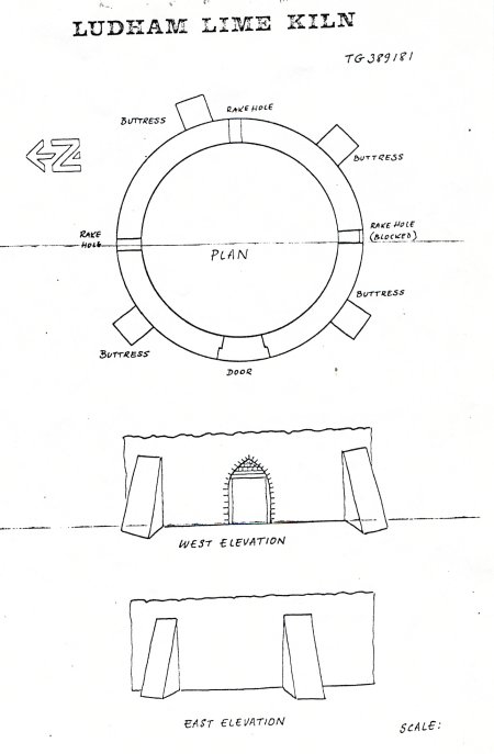
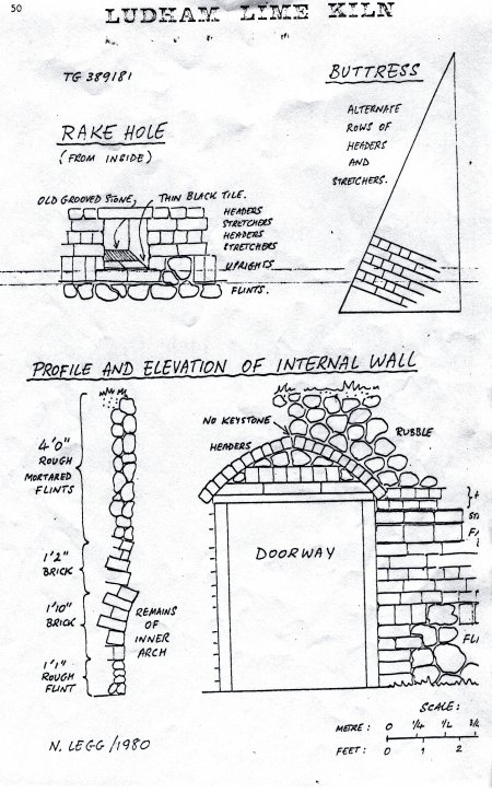
7. Limeburning
The lime kiln in Ludham seems to have been of the same type as the one at Acle Bridge. It was close to the river and above ground. The remains have been surveyed (see illustations)
8. Blacksmiths
From Norfolk Directories:
White 1845
Edm. Annison Blacksmith and Wheelwright
Thos. Thurgate Blacksmith
Benj. Varley Blacksmith
Rd. Forder Farrier and Cow Leech
White 1854
Rbt. Ames Wheelwright and Smith
Wm. Beck Blacksmith
Kelly 1888
John Chaplin Jnr. Carpenter, Wheelwright and Blacksm:
John Thos. Thurgate Blacksmith and P.O.
Kelly 1908
John Bower Blacksmith
Hy. Bush Blacksmith, Wheelwright and Carpent
Kelly 1922
Hy. Bush Blacksmith .
Kelly 1925
No entry
Kelly 1928
John Bower Blacksmith
Hy. Bush Blacksmith
Kelly 1929
No entry
Kelly 1937
Percy Salmond Blacksmith
Positions of Smithies:
(a) at the Stocks Hill end of StaitheSoad "Smithy_" is shown just inside the Manorgrounds on the 1884 6" and the 1885 25" Ordnance Maps, while Mrs. B. Cowing has also heard that the blacksmith Varley had his forge behind the cottages next to the Manor gates. There is also said to have been a smithy in the range of one storey buildings opposite the gates. It is not known if all these premises were in use at the same time or if they constituted one business;
(b) behind "Dormers", which is in Norwich Road opposite the church. This was also a wheelwright's. The smiths were Thurgate and then Salmond, and the wheelwright Mr. Bush;
(c) in School Road in the premises now occupied by Ludham Marina. This business was taken over by Mr. Anderson, blacksmith, just before the last war. When the use of horses on farms declined, he turned to making such items as firegrates. Mrs. Anderson, who still lives in Ludham, says he did make a few gates but she believes there are none in Ludham. The business closed in 1955.
There are handsome iron gates at How Hill Farm, Laurels Farm and The Grange. These are all made to one design with ornamental scrolls on the top bar, and appear to be peculiar to Ludham, which suggests that they were made by a local blacksmith. Mr. Clifford Kittle, who was born in 1904 and brought up at How Hill Farm, remembers the gates from his childhood and thinks they were almost certainly made by a local smith but he does not know which one. Mr. Alfred Mattocks says that the gates at Laurels Farm were old when his parents bought the property in the 1890s; he thinks the gates must be well over one hundred years old. (Incidentally, Mr. Mattocks mentioned that the wrought iron gates to the bungalow "Willowdale", in Norwich Road, were made in the 1960s by the well known blacksmith, Mr. Eric Stevenson, of Wroxham.)
There appears to be no instance in Ludham of a service garage having replaced a smithy. Ludham Garage in High Street stands on the site of the previous millwright's shop and Norwich Road Garage was started since the second war, replacing only a cartshed. The present foundry for non-ferrous metals has evolved from a cycle repair business.
It is possible that the iron bracket supporting the sign at the "King's Arms" was made at the same smithy as the gates mentioned. It has a similar ornamental scroll and has been in existence as long as anyone remembers.
9. Postal Service
Through mud and potholes the mail would come to Ludham. At first, public dispatches were sent by special messengers, private letters by servants or the Common Carrier.
Posting houses were first established during the reign of Edward I, chiefly for the King's messengers. In the next reign they began to be used by private couriers. In Elizabethan times a postal service for government affairs was set up for letters to the continent. About 1605 the first Postmaster General for Foreign Parts was appointed, and in 1635, by Royal proclamation, a service of messengers along eight main routes was established. The charge was 2d a letter, which was a considerable sum in those days. Ludham was obviously served by messengers, particularly from Norwich to St. Benet's Abbey, which was an important route in medieval days. There were six highways in Ludham, the rest being tracks leading to farms. Later the carriers' carts would transport mail and packages. Robert Newton, who lived at the "Rose and Crown" in 1854 was postmaster for thirty-three years. He died in 1873 aged 80. The inn became known as ''"The Crown" in later years and is now known as "Crown House".
In 1883 John Thurgate was postmaster and then in 1896 James Thurgate was parish clerk and postmaster. • He lived in the Norwich Road area and held the post office In the end room of "Dormers". The bricked up doorway can still be seen. Hence, the present Norwich Road was known as the "Old Post Office Street" for a time
.
A John Chaplin was also known to have been a postmaster at some date. He may have possibly been the same man who built the Methodist Church in 1867. By 1908 Ernest Alma Dale, who lived in Church View - an interesting house of many storeys - was postmaster, as well as being Inspector of Public Nuisances to Smallburgh Rural District Council.
In 1920 John Dale became postmaster until he became head of Dale, Rich & Clarke, a local firm of builders and undertakers. Then, by 1929, George and Helen Thrower were at the present post office and the telegraph system had advanced to the more modern telephone. Letters were collected and delivered twice daily. In addition, the Eastern Counties bus service was operating daily runs to Norwich and Yarmouth. The buses would accept letters and had a small box for mail beside the driver's cab on the outside of the bus.
Incidentally, in 1981 Mrs. H. Thrower is still postmistress and has given many years of valuable service.
The last mail to be stamped with a Ludham postmark was on Monday, 7 January 1980. The mail is now collected twice daily and taken to Great Yarmouth to be franked.
10. Oral Tradition
1 would like to record a few of the things I remember.
Today children have to go to London or somewhere for their Sunday School outing. We, on the other hand, were very, very happy to go as far as Sea Palling in the farm waggons. In the summer it was a treat to see the Four in Hand carriages bringing people from Yarmouth for a day's outing, We boys would run behind and the people would throw pennies out for us to catch. These carriages were called brakes.
I suppose most villages had their own little businesses. I well remember the trading wherries coming to Womack (Wannack) Staithe with loads of stone for the roads. They would dump it on the staithe, perhaps thirty tons at a time. Then the local contractor would cart it with horse and tumbril to selected spots on the verges. I have seen the roadman sitting on a sack on the stone heaps, breaking the larger stones. Then he would put them in the potholes in the roads. Just after the First World War, 1920 or '21, we were surprised to see men with brooms sweeping stones and dust from the roads. They had with them a big iron boiler with a fire underneath, drawn by a horse. They would spread the hot tar on the cleaned roads and then throw sand over it. Until the coming of tarmac and granite chips, the tar would come through the sand in the hot summer weather and stick to your feet. It was just about this time that the United Bus Co. started a service from Yarmouth to Ludham. Later they came right through to Norwich.
I well remember the first car in Ludham, owned by Dr. Gordon. It was exactly like one would see today in the London to Brighton run.
Notes on:
a) Womack Water
Wherries used the staithe. Chalk was brought from pits at Thorpe for lime-burning. Nineteenth century trade centred round the wherries and this water access.
Although spelled Womack today, the long-established residents pronounce the name as 'Wannock'. Little information has been found so far on the origin of the name or on the setting up of the staithe. Womack Water seems to have been enlarged in the mid-nineteenth century.
Wherries were built here. 'Albion' moors here. The staithe provides mooring for holiday craft today, bringing trade to the remaining shops.
b) Recent Industry
The manor house has become recently a centre for small crafts, notably the making of musical instruments by hand in wood.
Lotus has a base here, connected with car manufacturer.
c) A World War II Rarity
Still to be seen in the grounds of the manor are army latrines which sport Norfolk reed thatch.
d) Other Industries
Some other small industries may be found in the following list e.g. tanyard, but records of them have not been found so far.
Bibliography
Harrod's Postal and Commercial Directory
Kelly's Directory
White's Directory
Sale Records. Spelmans; Norfolk Record Office
'Action Stations: East Anglian Airfields', by M.J. Bower, pub. by Patrick Stephens Ltd.
Rye MS. 3, Vol. 2., Norfolk Record Office
This survey has been compiled by members of the Ludham W.E.A. class following a course in Industrial Archaeology held in 1980.
L. Carter J. Clarke C. England P. Goody B. Cowing D. Hayes
M. Hayes S. Hayton M. Keeler N. Legg J. McLennan O. Mason
D. Sayer J. Sayer M. Walton B. Winwood J. Young P. Young
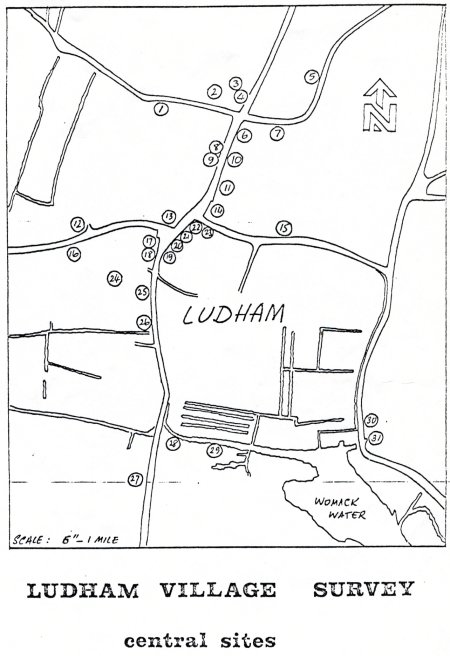
Ludham Village Survey - Central Sites
(key to map) Taken from various directories
1. The Smithy, School Road
2. The Board School, School Road,
3. High Street Methodist Chapel (ex Wesleyan)
4. Cook's Shop - General Stores from early 20th C. (prev. cycle shop)
5. Baptist Chapel (site of), Malthouse Lane
Site of windmill (corn) previously ) i,...;., ..'
6. Glover (and thatcher'), Wm. Grapes, The Firs, The Street, 1883
7. Steam-driven corn mill, Malthouse Lane
8. Kirby England, Butcher, Ham Smoker, etc., Ray House, The Street, 1883
9. England, Millwright, The Street (and engineer, brassfounder, ironfounder, maker and inventor of the patent turbine for fen drainage, 1883 10. Boot and shoe maker (1908), Harold Brooks, Latchmore, The Street
11. Police House, E. side of The Street (3-storey building and cells below)
12. Fish dealer and Oak Smoker, Eldridge Slaughter, 1908, Norwich Road, opposite Church Room
13. The King's Arms P.H.
The Royal Oak P.H.
Saddler & Harness Maker, Norwich Road - next to King's Arms
The Old Post Office
The Smithy, now 'Dormers', Norwich Road
Wheelwright and Carpenter's Shop, Norwich Road
14. The Baker's Arms P.H.
Bakery - at Baker's Arms (1854) )
Bricklayers - Wm. Davey & Son (1845), lived at Baker's Arms
15. Glover (1845), Rose Cottage, Yarmouth Road
16. The National School, Church Room? 1870s
17. The Post Office
18. The Royal Exchange P.H.
19. The Smithy, Johnson's Street
20. Fish Merchant, Harry Grapes, 1922, Stocks Hill (opposite Post Office)
21. Fred Lyon, Grocer & Draper, agent for Norwich Equitable Insurance (now Gowers Butcher's Shop), Stocks Hill
22. The (Rose &) Crown P.H.
Corn & Coal Merchant, Shipping Agent and agent for emigration, Ebenezer Newton, at the Rose & Crown
The Dame School, Rose Villa, Yarmouth Road
Clarissa Fairhead (Draper), Stocks Hill, (next to Gowers)
23. The Ship P.H.
Carrier - A. Beevor, Yarmouth Road
24. St. Catherine's Church (C. of E.)
25. The Spread Eagle P.H. The Bakery, Staithe Road)
26. The Town House (poorhouse), top end of Staithe Road
27. Baptist Chapel (site of), Staithe Road
28. The Excise Officer (1845), Staithe House, Staithe Road
Surgeon and Physician, M.O.H. Vaccinator and Registrar, from late 19th C.
Corn, Coal and Manure Merchant, Farmer and Wine and Spirit Merchant,) John Clarke, Staithe House
29. Lime Kiln, Staithe House
30. Maltings, The Staithe, Horse Fen Road
31. Brick Kiln, The Staithe
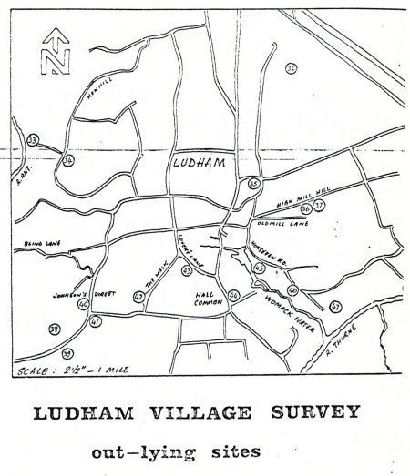
Outlying Sites
32„.....1x=2nd World War Airfield (now farmland and Westwick Crop Spraying airfield)
33. Skeleton Mill, How Hill river bank
34. How Hill Mill (corn)
35. Maltings, Malthouse Farm, Malthouse Lane
36. High Mill (corn), Yarmouth Road
37. Brick Kiln, High Mill Farm
38. Windpump, Ludham Bridge (right side leaving Ludham)
39. Beaumont's Mill (windpump) (left side leaving Ludham)
40. Johnston Street Methodist Church
Tanyards, near Stone House, Johnson Street)
41. The Dog P.H.
42. Farm Forge, The Hall (Bishop's Palace)
The Chapel, The Hall (Bishop's Residence)
43. Town Mill (corn), Lover's Lane
44. Bond, Fleet of Boats, Hall Common Farm, Staithe Road
45. Robt. & Wm. Harrison, Boat builders, 1836, Horse Fen Road (now Collings)
46. Hunter's Boatyard, Horse Fen Road - post 1st World War (now County Sailing Base)
47. Ewle's Mill (drainage) beyond Horse Fen Road
48. River Bank Mill, beyond Lower Farm, Fritton
Sites not shown on Map (Appendix to key)
Carrier (Rice) address ?
Wm. Lincoln, 1888
George Lincoln and Walter Lincoln 1883 - Bricklayers somewhere in Yarmouth Road
Undertakers - Wm. Ritches, Bob Mattocks and Pat Thrower
Tailors - Colman, Geo. Smith and Geo. Smith Junior - business locations unknown
Prat, Corn Miller and Wherry Owner, address unknown
Wm. Pigg,-Wherry Owner
Samuel Hicks, Wherry Owner, Staithe Road
Grapes, Thatcher, The Street, 1908
Grapes, Thatcher, Bowes House, Johnson Street (Generations of Grapes thatched, but moved house from time to time - 1850s on.)
 |
 |
 |
 |