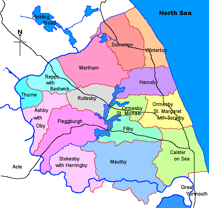
Why Flegg Island?
When the Romans arrived at Caister 2000 years ago the Flegg
area was very different. It would have been possible to have walked north from
Caister to Winterton but then your progress northward would have been halted by a
large shallow estuary. The Hundred Stream, which now flows south-west into the
River Thurne, was then flowing eastward into the North Sea. To the east was the
North Sea so you may well have turned west hoping to find somewhere to cross.
If you were not prepared to get your feet wet, after a very long walk, you’d have
arrived back at Caister.
One obvious feature of the Flegg area is that even now it is almost completely surrounded by water of one sort or another. To the north is the Hundred Stream which flows southwest into Somerton. It then joins the River Thurne which continues to flow in more or less the same direction until the River Thurne itself joins the River Bure. The River Bure then forms much of the western and southern boundery of the Flegg area.
Flegg Broads
At the very centre of Flegg are the Trinity Broads. The most northerly of these is
Rollesby Broad, the central one Ormesby Broad and the most southerly, Filby Broad. There
is a small sailing club on Rollesby Broad and the Norfolk Schools’ Sailing Association has
the use of Filby Broad. The only other craft to be found are rowing boats used either by
anglers or those out for a pleasant row. There’s not a single motor cruiser or yacht
to be seen. The broads drain into the River Bure via Fleggburgh Muck Fleet. I have seen
it referred to, incorrectly, as the Musk Fleet. As a young lad I once fell in it and I can
assure you that ‘Muck’ describes it far more accurately than ‘Musk’!
Further north, in the village of Martham, is yet another broad which is fed, and drained, by the River Thurne. Martham Broad is quite different in origin, having been formed by the extraction of clay in the Middle Ages whilst the larger and much deeper Trinity Broads were formed by peat cutting in medieval times.
Village Place–names
The majority are Danish in origin with a few interesting exceptions. The majority of
village names end in ‘by’. Of these, Filby is the only village whose name can
be compared with an existing village in Denmark, namely that of Fielby. There are only
three other villages elsewhere in Norfolk with the ‘by’ ending. Neither
Winterton nor Somerton appear to be Danish but in Lincolnshire there’s another area which
also has a large number of Danish place–names. Amongst these are two more villages named
Winterton and Somerton. Caister is of Roman origin. Repps, Bastwick, Thurne and Martham
are Old English names. Flegg itself is probably Old Norse, meaning a place where water
plants or flags could be found. This just leaves the hamlet of California. On May 11th,
1848 a quantity of sixteenth century gold coins was found at the foot of the cliffs at
Scratby. A group of Winterton beachmen must have concluded that the cliff above the site
of the find would make a good site for a new lookout. At the same time the California
gold rush in America was much in the news. The beachmen decided that their new site
needed a name – and California, Norfolk came into being. By 1851 houses were being
built there. By 1861 when the next population census was taking place the population of
this new hamlet had risen to almost two hundred. By 1870 over forty houses had been
built, plus the original California Tavern. It was in one of these houses, overlooking the sea,
that my father was born in 1900.
The two most populous villages are Caister and Martham. The village of Runham, one of the most southerly areas of Flegg, has lost its pub and school within the last thirty years or so.
Transport
The three most important roads are the B1159 coast road through Caister, Ormesby, Hemsby and
Winterton, the A1064 from Caister through Filby and Fleggburgh which leads on to Acle and
Norwich and the A149 through Ormesby, Rollesby and Repps with Bastwick. There are many
more minor roads which traverse the countryside. One interesting point is that Fadon’s
map of Norfolk, dated 1797 shows many more roads which have now disappeared!
Another interesting point is that all three roads mentioned cross bridges. You’ll
have to look hard to notice the one over the Hundred Stream but it’s there,
nevertheless. The only way that one can leave Flegg Island without crossing water is to
walk northwards along the beach or dunes from Winterton into the parish of Horsey.
Rail transport first came to the Flegg area when the railway line between Great Yarmouth and Ormesby opened on 7th August, 1877. Hemsby railway station opened on 16th May, 1878 and on 15th July in the same year the railway line reached Martham. The line was to remain open until 2nd March, 1959.
Did You Know?
Centuries ago Scratby had its own parish church. It was demolished in 1548 and the curacy
transferred to Ormesby St. Margaret which in that same year had the curacy of Ormesby St. Michael
transferred to it as well.
Although Flegg Island cannot boast the likes of Stonehenge, a polished flint axe-head has been found in Rollesby. It could have been manufactured any time between 2500 and 6000 years ago.
Flegg Island boasts its own castle whose history is well documented. It was built in Caister on the site of a former manor house. Building commenced on 6th January, 1433 and was finally completed in 1448. What makes the castle unique is that it was the first castle in England to be built of brick. It is open to the public.
The highest point on Flegg Island is 22m above sea level. It lies just north of Blood Hills in Somerton. Just south of Blood Hills lies Gibbet Hill.
And finally – Parish Records